Pymartini Save
A Cython port of Martini for fast RTIN terrain mesh generation
pymartini
A Cython port of Martini for fast RTIN terrain mesh generation, 2-3x faster than Martini in Node. The only dependency is Numpy.
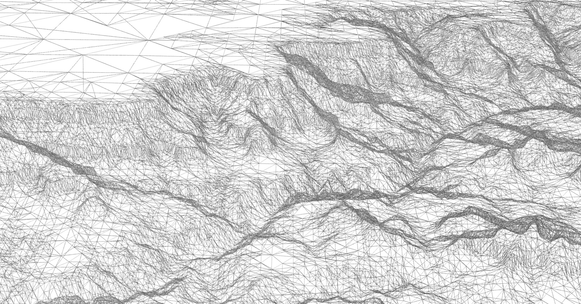
A wireframe rendering of the Grand Canyon. The mesh is created using
pymartini, encoded using quantized-mesh-encoder,
served on-demand using dem-tiler, and rendered with
deck.gl.
Install
With pip:
pip install pymartini
or with Conda:
conda install -c conda-forge pymartini
Using
Example
The API is modeled after Martini.
from pymartini import Martini

# set up mesh generator for a certain 2^k+1 grid size
# Usually either 257 or 513
martini = Martini(257)

# generate RTIN hierarchy from terrain data (an array of size^2 length)
tile = martini.create_tile(terrain)

# get a mesh (vertices and triangles indices) for a 10m error
vertices, triangles = tile.get_mesh(10)
API
The Martini class and create_tile and get_mesh methods are a direct port
from the JS Martini library.
Additionally I include two helper functions: decode_ele to decode a Mapbox
Terrain RGB or Terrarium PNG array to elevations; and rescale_positions, which
adds elevations to each vertex and optionally linearly rescales each vertex's XY
coordinates to a new bounding box.
Martini
A class to instantiate constants needed for the create_tile and get_mesh
steps. As noted in the benchmarks below, instantiating the Martini class is
the slowest of the three functions. If you're planning to create many meshes of
the same size, create one Martini class and create many tiles from it.
Arguments
-
grid_size(int, default257): the grid size to use when generating the mesh. Must be 2^k+1. If your source heightmap is 256x256 pixels, usegrid_size=257and backfill the border pixels.
Returns
Returns a Martini instance on which you can call create_tile.
Martini.create_tile
Generate RTIN hierarchy from terrain data. This is faster than creating the
Martini instance, but slower than creating a mesh for a given max error. If
you need to create many meshes with different errors for the same tile, you
should reuse a Tile instance.
Arguments
-
terrain(numpyndarray): an array of dtypefloat32representing the input heightmap. The array can either be flattened, of shape (2^k+1 * 2^k+1) or a two-dimensional array of shape (2^k+1, 2^k+1). Note that for a 2D array pymartini expects indices in (columns, rows) order, so you might need to transpose your array first. Currently an error will be produced if the dtype of your input array is notnp.float32.
Returns
Returns a Tile instance on which you can call get_mesh.
Tile.get_mesh
Get a mesh for a given max error.
Arguments
-
max_error(float, default0): the maximum vertical error for each triangle in the output mesh. For example if the units of the input heightmap is meters, usingmax_error=5would mean that the mesh is continually refined until every triangle approximates the surface of the heightmap within 5 meters.
Returns
Returns a tuple of (vertices, triangles).
Each is a flat numpy array. Vertices represents the interleaved 2D
coordinates of each vertex, e.g. [x0, y0, x1, y1, ...]. If you need 3D
coordinates, you can use the rescale_positions helper function described
below.
triangles represents indices within the vertices array. So [0, 1, 3, ...] would use the first, second, and fourth vertices within the vertices
array as a single triangle.
decode_ele
A helper function to decode a PNG terrain tile into elevations.
Arguments
-
png(np.ndarray): Ndarray of elevations encoded in three channels, representing red, green, and blue. Must be of shape (tile_size,tile_size,>=3) or (>=3,tile_size,tile_size), wheretile_sizeis usually 256 or 512 -
encoding(str): Either 'mapbox' or 'terrarium', the two main RGB encodings for elevation values -
backfill(bool, defaultTrue): Whether to create an array of size (tile_size + 1,tile_size + 1), backfilling the bottom and right edges. This is used because Martini needs a grid of size2^n + 1
Returns
- (
np.ndarray) Array with decoded elevation values. IfbackfillisTrue, returned shape is (tile_size + 1,tile_size + 1), otherwise returned shape is (tile_size,tile_size), wheretile_sizeis the shape of the input array.
Example
from imageio import imread
from pymartini import decode_ele

path = './test/data/fuji.png'
fuji = imread(path)
terrain = decode_ele(fuji, 'mapbox')
rescale_positions
A helper function to rescale the vertices output and add elevations. The
output is a numpy ndarray of the form [[x1, y1, z1], [x2, y2, z2], ...].
Arguments
-
vertices: (np.array) vertices output from Martini -
terrain: (np.ndarray) 2d heightmap array of elevations as output bydecode_ele. Expected to have shape (grid_size,grid_size).terrainis expected to be the exact same array passed toMartini.create_tile. If you use a different or transposed array, the mesh will look weird. See #15. If you need to transpose your array, do it before passing toMartini.create_tile. -
bounds: (List[float], defaultNone) linearly rescale position values to this extent, expected to be [minx, miny, maxx, maxy]. If not provided, no rescaling is done -
flip_y: (bool, defaultFalse) Flip y coordinates. Can be useful when original data source is a PNG, since the origin of a PNG is the top left.
Example
from imageio import imread
from pymartini import decode_ele, Martini, rescale_positions

path = './test/data/terrarium.png'
png = imread(path)
terrain = decode_ele(png, 'mapbox')
martini = Martini(png.shape[0] + 1)
tile = martini.create_tile(terrain)
vertices, triangles = tile.get_mesh(10)

# Use mercantile to find the bounds in WGS84 of this tile
import mercantile
bounds = mercantile.bounds(mercantile.Tile(385, 803, 11))

# Rescale positions to WGS84
rescaled = rescale_positions(
    vertices,
    terrain,
    bounds=bounds,
    flip_y=True
    column_row=True
)
Martini or Delatin?
Two popular algorithms for terrain mesh generation are the "Martini"
algorithm, found in the JavaScript martini library and this Python
pymartini library, and the "Delatin" algorithm, found in the
C++ hmm library, the Python pydelatin library, and the JavaScript
delatin library.
Which to use?
For most purposes, use pydelatin over pymartini. A good breakdown from a
Martini issue:
Martini:
- Only works on square 2^n+1 x 2^n+1 grids.
- Generates a hierarchy of meshes (pick arbitrary detail after a single run)
- Optimized for meshing speed rather than quality.
Delatin:
- Works on arbitrary raster grids.
- Generates a single mesh for a particular detail.
- Optimized for quality (as few triangles as possible for a given error).
Correctness
pymartini passes the (only) test case included in the original Martini JS
library. I also wrote a few extra conformance tests to compare output by
pymartini and Martini. I've found some small differences in float values at
the end of the second step.
This second step, martini.create_tile(terrain), computes the maximum error of
every possible triangle and accumulates them. Thus, small float errors appear to
be magnified by the summation of errors into larger triangles. These errors
appear to be within 1e-5 of the JS output. I'm guessing that this variance is
greater than normal float rounding errors, due to this summation behavior.
These differences are larger when using 512px tiles compared to 256px tiles, which reinforces my hypothesis that the differences have something to do with small low-level float or bitwise operations differences between Python and JavaScript.
If you'd like to explore this in more detail, look at the Tile.update() in
martini.pyx and the corresponding Martini code.
Type Checking
As of pymartini 0.4.0, types are provided, which can be used with a checker
like mypy. If you wish to get the full
benefit, make sure to enable Numpy's mypy
plugin.
Benchmark
Preparation steps are about 3x faster in Python than in Node; generating the mesh is about 2x faster in Python than in Node.
Python
git clone https://github.com/kylebarron/pymartini
cd pymartini
pip install '.[test]'
python bench.py
init tileset: 14.860ms
create tile: 5.862ms
mesh (max_error=30): 1.010ms
vertices: 9700.0, triangles: 19078.0
mesh 0: 18.350ms
mesh 1: 17.581ms
mesh 2: 15.245ms
mesh 3: 13.853ms
mesh 4: 11.284ms
mesh 5: 12.360ms
mesh 6: 8.293ms
mesh 7: 8.342ms
mesh 8: 7.166ms
mesh 9: 5.678ms
mesh 10: 5.886ms
mesh 11: 5.092ms
mesh 12: 3.732ms
mesh 13: 3.420ms
mesh 14: 3.524ms
mesh 15: 3.101ms
mesh 16: 2.892ms
mesh 17: 2.358ms
mesh 18: 2.250ms
mesh 19: 2.293ms
mesh 20: 2.281ms
20 meshes total: 155.559ms
JS (Node)
git clone https://github.com/mapbox/martini
cd martini
npm install
node -r esm bench.js
init tileset: 54.293ms
create tile: 17.307ms
mesh: 6.230ms
vertices: 9704, triangles: 19086
mesh 0: 43.181ms
mesh 1: 33.102ms
mesh 2: 30.735ms
mesh 3: 25.935ms
mesh 4: 20.643ms
mesh 5: 17.511ms
mesh 6: 15.066ms
mesh 7: 13.334ms
mesh 8: 11.180ms
mesh 9: 9.651ms
mesh 10: 9.240ms
mesh 11: 10.996ms
mesh 12: 7.520ms
mesh 13: 6.617ms
mesh 14: 5.860ms
mesh 15: 5.693ms
mesh 16: 4.907ms
mesh 17: 4.469ms
mesh 18: 4.267ms
mesh 19: 4.267ms
mesh 20: 3.619ms
20 meshes total: 290.256ms
License
This library is ported from Mapbox's Martini, which is licensed under the ISC License. My additions are licensed under the MIT license.
ISC License
Copyright (c) 2019, Mapbox
Permission to use, copy, modify, and/or distribute this software for any purpose with or without fee is hereby granted, provided that the above copyright notice and this permission notice appear in all copies.
THE SOFTWARE IS PROVIDED "AS IS" AND THE AUTHOR DISCLAIMS ALL WARRANTIES WITH REGARD TO THIS SOFTWARE INCLUDING ALL IMPLIED WARRANTIES OF MERCHANTABILITY AND FITNESS. IN NO EVENT SHALL THE AUTHOR BE LIABLE FOR ANY SPECIAL, DIRECT, INDIRECT, OR CONSEQUENTIAL DAMAGES OR ANY DAMAGES WHATSOEVER RESULTING FROM LOSS OF USE, DATA OR PROFITS, WHETHER IN AN ACTION OF CONTRACT, NEGLIGENCE OR OTHER TORTIOUS ACTION, ARISING OUT OF OR IN CONNECTION WITH THE USE OR PERFORMANCE OF THIS SOFTWARE.
