Maxar Open Data Save
The Maxar Open Data STAC Catalog in CSV, GeoJSON, and MosaicJSON formats
Project README
maxar-open-data
Introduction

![]()
![]()

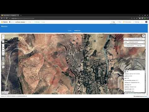
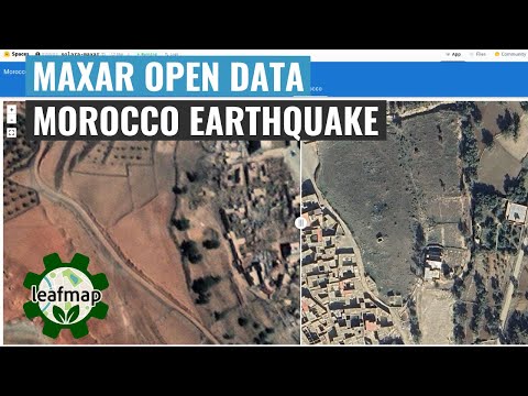
The Maxar Open Data Program provides pre- and post-event high-resolution satellite imagery in support of emergency planning, risk assessment, monitoring of staging areas and emergency response, damage assessment, and recovery. Check out the links below for more information.
- Maxar Open Data Program
- Maxar Open Data on AWS
- Maxar Open Data on STAC Index
- Maxar Open Data on STAC Browser
- Maxar Open Data on Hugging Face
The Maxar Open Data STAC catalog URL is: https://maxar-opendata.s3.amazonaws.com/events/catalog.json. The repo contains the catalog in various formats, including GeoJSON, CSV, and MosaicJSON. This makes it easier to use the datasets with Python and other programming languages.
Examples
Visualizing image footprints
import leafmap
m = leafmap.Map(center=[36.844461, 37.386475], zoom=8)
url = 'https://github.com/opengeos/maxar-open-data/raw/master/datasets/Kahramanmaras-turkey-earthquake-23.geojson'
m.add_geojson(url, layer_name="Footprints")
m

Visualizing COG mosaic
m = leafmap.Map()
url = 'https://open.gishub.org/maxar-open-data/datasets/Kahramanmaras-turkey-earthquake-23/1050050044DE7E00.json'
m.add_stac_layer(url, name="Mosaic")
m

Relevant Projects
- A list of open datasets on AWS: aws-open-data
- A list of open geospatial datasets on AWS: aws-open-data-geo
- A list of open geospatial datasets on AWS with a STAC endpoint: aws-open-data-stac
- A list of STAC endpoints from stacindex.org: stac-index-catalogs
- A list of geospatial datasets on Microsoft Planetary Computer: Planetary-Computer-Catalog
- A list of geospatial datasets on Google Earth Engine: Earth-Engine-Catalog
- A list of geospatial datasets on NASA's Common Metadata Repository (CMR): NASA-CMR-STAC
- A list of geospatial data catalogs: geospatial-data-catalogs
- The Maxar Open Data STAC Catalog: maxar-open-data
- A Solara web app for visualizing Maxar Open Data: solara-maxar
Demo
Tutorial
Open Source Agenda is not affiliated with "Maxar Open Data" Project. README Source: opengeos/maxar-open-data
Stars
196
Open Issues
1
Last Commit
2 months ago
Repository
License
