Geogramint Save
An OSINT Geolocalization tool for Telegram that find nearby users and groups 📡🌍🔍
Geogramint - OSINT Geolocalization tool for Telegram


About
Geogramint is an OSINT tool that uses Telegram's API to find nearby users and groups. Inspired by Tejado's Telegram Nearby Map, which is no longer maintained, it aims to provide a more user-friendly alternative.
Geogramint only finds Telegram users and groups which have activated the nearby feature. Per default it is deactivated.
The tool is fully supported on Windows and partially supported on Mac OS and Linux distributions.
🛠️ Installation
Requirements: Python 3.8 or 3.9
On Windows 

-
With the installer: Click here!
-
With Github:
git clone https://github.com/Alb-310/Geogramint.git
cd Geogramint/
pip3 install -r requirements.txt

python3 geogramint.py # for GUI mode
python3 geogramint.py --help # for CLI mode
Or depending on your installation :
git clone https://github.com/Alb-310/Geogramint.git
cd Geogramint/
pip install -r requirements.txt

python geogramint.py # for GUI mode
python geogramint.py --help # for CLI mode
On Mac OS  and Linux
git clone https://github.com/Alb-310/Geogramint.git
cd Geogramint/
pip3 install -r requirements.txt

python3 geogramint.py # for GUI mode
python3 geogramint.py --help # for CLI mode
Or depending on your installation :
git clone https://github.com/Alb-310/Geogramint.git
cd Geogramint/
pip install -r requirements.txt

python geogramint.py # for GUI mode
python geogramint.py --help # for CLI mode
More details in the Wiki.
📡 Example: GUI
- Start by creating an API key for your Telegram account here. You will also need to put a profile picture on your account and, in your
Privacy and Securitysettings, enable the profile picture for everyone.

- Launch Geogramint
- In the settings, write your information (api_id, api_hash and phone number), report preference and then
save


- Choose the location where you want to search, either by moving around the map or by using the search feature with coordinates in
lat, lonformat

- Telegram will send you a verification code, write it in the pop-up window (+ your two-step verification password if you have one)

- Then click
Start Search - All results will be displayed following:
- green for 500m
- yellow for 1000m
- orange for 2000m
- red for >3000m
(NB: results can also be found in Geogramint/cache_telegram/ in json and csv format + profiles pictures)

-
Resetwill clear the results and erase thecache_telegram
More details in the Wiki.
📡 Example: CLI
- Start by creating an API key for your Telegram account here. You will also need to put a profile picture on your account and, in your
Privacy and Securitysettings, enable the profile picture for everyone.
- Launch Geogramint

- Start with the config, with the command
set-configset your information (api_id, api_hash and phone number)

- Start the search feature by using coordinates in
lat lonformat with the commandstart-scan:


⬇
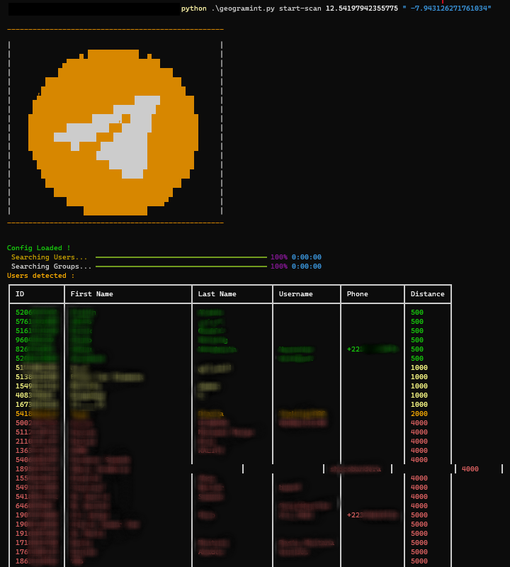
- All results will be displayed following:
- green for 500m
- yellow for 1000m
- orange for 2000m
- red for >3000m
(NB: results can be exported depending options used with start-scan, by default profile pictures and results in json format are present in Geogramint/cache_telegram/)
-
reset-scanwill clearcache_telegram
More details in the Wiki.
📖 Wiki
Remember to check the Wiki before posting an issue or asking a question.
📝 License
GNU General Public License v3.0
🙏 Thanks to:
- My teammates at Projet FOX
- sergiombd
